5 min read
Preparations for Next Moonwalk Simulations Underway (and Underwater)

The novel approach to estimating river water storage and discharge also identifies regions marked by ‘fingerprints’ of intense water use.
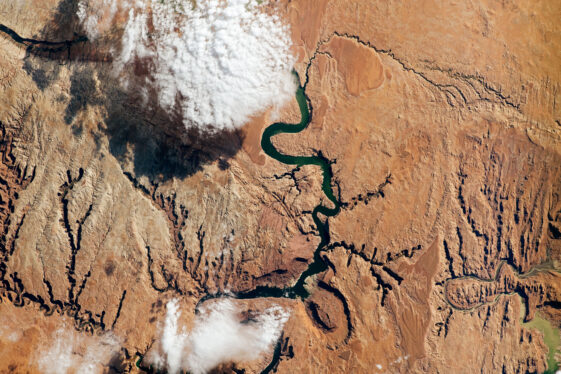
A study led by NASA researchers provides new estimates of how much water courses through Earth’s rivers, the rates at which it’s flowing into the ocean, and how much both of those figures have fluctuated over time — crucial information for understanding the planet’s water cycle and managing its freshwater supplies. The results also highlight regions depleted by heavy water use, including the Colorado River basin in the United States, the Amazon basin in South America, and the Orange River basin in southern Africa.
For the study, which was recently published in Nature Geoscience, researchers at NASA’s Jet Propulsion Laboratory in Southern California used a novel methodology that combines stream-gauge measurements with computer models of about 3 million river segments around the world.

The scientists estimate that the total volume of water in Earth’s rivers on average from 1980 to 2009 was 539 cubic miles (2,246 cubic kilometers). That’s equivalent to half of Lake Michigan’s water and about 0.006% of all fresh water, which itself is 2.5% of the global volume. Despite their small proportion of all the planet’s water, rivers have been vital to humans since the earliest civilizations.
Although researchers have made numerous estimates over the years of how much water flows from rivers into the ocean, estimates of the volume of water rivers collectively hold — known as storage — have been few and more uncertain, said JPL’s Cédric David, a co-author of the study.
He likened the situation to spending from a checking account without knowing the balance. “We don’t know how much water is in the account, and population growth and climate change are further complicating matters,” David said. “There are many things we can do to manage how we’re using it and make sure there is enough water for everyone, but the first question is: How much water is there? That’s fundamental to everything else.”
Estimates in the paper could eventually be compared with data from the international Surface Water and Ocean Topography (SWOT) satellite to improve measurements of human impacts on Earth’s water cycle. Launched in December 2022, SWOT is mapping the elevation of water around the globe, and changes in river height offer a way to quantify storage and discharge.
‘Fingerprints’ of Water Use
The study identified the Amazon basin as the region with the most river storage, holding about 204 cubic miles (850 cubic kilometers) of water — roughly 38% of the global estimate. The same basin also discharges the most water to the ocean: 1,629 cubic miles (6,789 cubic kilometers) per year. That’s 18% of the global discharge to the ocean, which averaged 8,975 cubic miles (37,411 cubic kilometers) per year from 1980 to 2009.
Although it’s not possible for a river to have negative discharge — the study’s approach doesn’t allow for upstream flow — for the sake of accounting, it is possible for less water to come out of some river segments than went in. That’s what the researchers found for parts of the Colorado, Amazon, and Orange river basins, as well as the Murray-Darling basin in southeastern Australia. These negative flows mostly indicate intense human water use.
“These are locations where we’re seeing fingerprints of water management,” said lead author Elyssa Collins, who conducted the analysis as a JPL intern and doctoral student at North Carolina State University in Raleigh.
A New Way to Quantify Rivers
For decades, most estimates of Earth’s total river water were refinements of a 1974 United Nations figure, and no study has illustrated how the amount has varied with time. Better estimates have been hard to come by, David said, due to a lack of observations of the world’s rivers, particularly those far from human populations.
Another issue has been that there are many more stream gauges monitoring the levels and flow of large rivers than there are of small ones. There’s also broad uncertainty in estimates of land runoff — the rainwater and snowmelt that flow into rivers.
The new study started from the premise that runoff flowing into and through a river system should roughly equal the amount that gauges measure downstream. Where the researchers found inconsistencies between simulated runoff from three land surface models and gauge measurements taken from approximately 1,000 locations, they used the gauge measurements to correct the simulated runoff numbers.
Then they modeled the runoff through rivers on a high-resolution global map developed using land-elevation data and imagery from space, including from NASA’s Shuttle Radar Topography Mission. This approach yielded discharge rates, which were used to estimate average and monthly storage for individual rivers and the planet’s rivers in total.
Using a consistent methodology enables comparisons in flow and human drawdown between different regions.
“That way we can see where in the world the most amount of river water is stored, or where the most amount of water is being emptied into oceans from rivers,” said Collins, now a postdoctoral researcher at the University of North Carolina at Chapel Hill.
News Media Contacts
Andrew Wang / Jane J. Lee
Jet Propulsion Laboratory, Pasadena, Calif.
626-379-6874 / 818-354-0307
andrew.wang@jpl.nasa.gov / jane.j.lee@jpl.nasa.gov
2024-051
Share
Details
Related Terms
https://www.nasa.gov/missions/swot/nasa-led-study-provides-new-global-accounting-of-earths-rivers/


